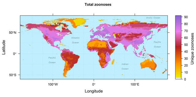
The map, created by the European Commission’s Joint Research Centre (JRC), provides a detailed visualization of outbreak risk zones. While it does not forecast specific events, it pinpoints regions where ecological disruption, climate variability, and human activity converge to elevate the potential for zoonotic diseases—those transmitted from animals to people. The data reveals that 6.3% of global land is classified as high-risk, with an additional 3% designated as very high-risk, underscoring the need for targeted surveillance in these areas.
The Geography of Risk: Where the Map Flashes Red
The JRC’s analysis reveals significant disparities in outbreak vulnerability across the globe. Latin America and Oceania emerge as particularly critical regions, where deforestation, urban expansion, and climate shifts are transforming ecosystems. These environmental changes have been associated with increased transmission risks for diseases that move between animals and humans.
The data offers a granular look at population exposure. Approximately 20% of the global population resides in areas classified as medium-risk, while 3% live in zones marked as high or very high-risk. Though this percentage may appear modest, it represents millions of individuals, many in countries where public health infrastructure faces resource constraints. The analysis identifies locations where both outbreak likelihood and response capacity require urgent attention.
The methodology behind the map integrates satellite observations with machine learning to detect patterns in land use, climate, and population density linked to past outbreaks. While not predictive in a strict sense, the tool provides a framework for assessing risk in ways that traditional epidemiological approaches may overlook. Researchers suggest that such models can help prioritize areas for early intervention and resource allocation.
Zoonotic Diseases: The Unseen Threat in the Shadows
The majority of diseases highlighted in the JRC’s assessment are zoonotic, originating in animals before crossing into human populations. Factors such as wildlife trade, land-use changes, and the expansion of human settlements into natural habitats are known to facilitate these transmissions. When forests are cleared for agriculture or development, the remaining species—often those adapted to disturbed environments—tend to be the ones carrying pathogens with potential human health impacts.
The scale of zoonotic risk is substantial. Studies indicate that about three-quarters of emerging human infections originate in animals. While this connection is well-documented, the JRC’s model quantifies how human activity influences these dynamics. Population density, for instance, emerged as a key factor in outbreak potential, often outweighing climate variables. Higher concentrations of people living near wildlife—and in close proximity to one another—increase the opportunities for viruses to find new hosts.
This risk is not confined to remote regions. The World Health Organization (WHO) has identified priority zoonotic threats, and these pathogens appear across the JRC’s risk zones. The conditions enabling their spread exist in areas where public health systems operate under significant strain, from the Amazon basin to Pacific island nations. The assessment underscores the need for strengthened surveillance and response capabilities in these settings.
Climate Change: The Silent Accelerator
The JRC’s findings reinforce that climate change is already reshaping the distribution of infectious diseases. Rising temperatures, shifting precipitation patterns, and more frequent extreme weather events are altering the habitats of animals, insects, and viruses. Mosquitoes that were once limited to tropical climates are now appearing in higher latitudes, expanding the reach of diseases like dengue and chikungunya. Similarly, ticks are moving into new territories, carrying pathogens such as those responsible for Lyme disease.
These changes are not speculative. Research has demonstrated that climate variability influences wildlife migration, breeding cycles, and habitat use, all of which can heighten the likelihood of contact between humans and disease-carrying animals. The JRC’s model indicates that longer warm seasons may extend the survival of disease vectors in regions where they were previously uncommon. In some areas, this shift means that seasonal outbreaks could become a persistent threat throughout the year.
Climate change interacts with other environmental pressures to amplify risks. Deforestation, for example, not only reduces biodiversity but can also create conditions where remaining species are more likely to harbor pathogens. When forests are fragmented by roads, agriculture, or mining, the animals that persist in these altered landscapes are often those that thrive near human activity. Research suggests these species are more likely to carry viruses with the potential to jump to humans.
What the Map Can—and Can’t—Tell Us
The JRC’s model serves as a valuable tool for understanding outbreak risk, though it has inherent limitations. It does not forecast specific events or identify particular pathogens. Instead, it highlights the environmental and demographic conditions that increase the likelihood of outbreaks, offering guidance on where surveillance and preparedness efforts should be concentrated. For public health officials, this information can help prioritize resource allocation.
A notable aspect of the findings is the disparity between risk levels and response capacity. The assessment reveals that many high-risk regions also face challenges in detecting and containing outbreaks. In these areas, healthcare infrastructure often operates under constraints, and disease surveillance resources may be limited. Environmental changes, including climate shifts and land development, further complicate these challenges by increasing outbreak risks while simultaneously straining response systems.
For communities in vulnerable regions, the map serves as a reminder of the interconnectedness between environmental and public health. The factors driving disease risk—such as deforestation, climate change, and urbanization—have direct implications for human well-being. The JRC’s analysis identifies areas where proactive measures could help mitigate future threats, emphasizing the importance of early action in high-risk zones.
The intersection of climate and land use will remain a critical focus. As temperatures rise and natural habitats shrink, the conditions for zoonotic spillover are likely to become more favorable. The JRC’s map is not a prediction of inevitable outcomes but a tool for understanding where risks are concentrated—and where opportunities for intervention exist. The question now is how this information will inform global health strategies moving forward.